The Route

From W 50th Street to Valley View Road — entirely along Highway 100's frontage corridor.

Willson Road runs along the east side of Highway 100 starting near Edina City Hall. Just south of Golf Terrace Heights, it continues as East Frontage Road, passing the Edina Community Center, South View Lane, and Benton Avenue, before meeting Valley View Road at W 60th Street.
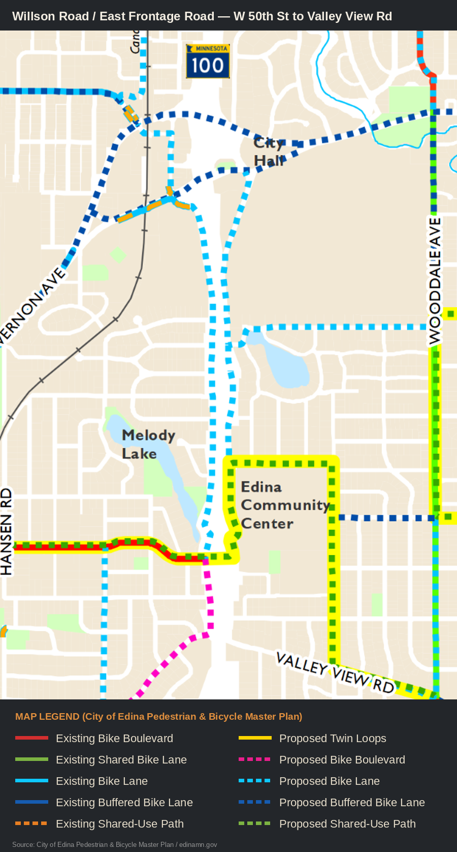
Map of the Willson Road and East Frontage Road area, from the City of Edina's Pedestrian and Bicycle Master Plan
Sourced from the City of Edina's own Pedestrian & Bicycle Master Plan map (edinamn.gov). Willson Road runs along the east side of Highway 100 starting near City Hall, becoming East Frontage Road past Golf Terrace Heights, continuing past the Edina Community Center toward Valley View Road. A highlighted/annotated version of this map is still in progress.
Coming Soon

A second graphic positioning this route within Edina's broader bike connectivity map, showing how it connects into the City's planned network at Benton Avenue and beyond.

Coming Soon

A photo of the Willson Road / East Frontage Road corridor itself — it runs through a genuinely park-like stretch that's worth seeing to appreciate why this route works so well.

Why This Route Works

Zero displacement, and it already fits into the City's own plans.

No homes, no compromise

The entire corridor has no adjacent houses.

A bike route here costs no resident their on-street parking and requires no compromise with any adjoining property owner — a rare thing for a corridor this length.

Already in the City's plan

It connects directly into the City's planned bike network at Benton Avenue.

Per the City's Pedestrian and Bicycle Master Plan, this isn't a detour around the City's plan — it's a sensible way to help fulfill it.

Two credible build options

Either striped lanes on the road, or a separated path in the right-of-way.

Willson Road and East Frontage Road are wide enough for dedicated bike lanes without removing anything. Alternatively, the City's existing right-of-way is wide enough for a physically separated path — an even safer outcome for cyclists.

Momentum already exists

Nearby infrastructure has just been rebuilt with room for active transportation.

The recently completed Vernon Avenue & Highway 100 interchange project added new pedestrian and multi-use infrastructure at the W 50th Street bridge over Highway 100 — right at this route's northern end. Residents have also noted potential connections to planned improvements along Vernon Avenue and Interlachen Boulevard, which would be worth confirming with the City as this route is developed further.

0Houses affected
0Parking spaces removed
2Buildable route options
For the Record

Two other compromise ideas our coalition proposed along the way.

These aren't needed anymore — the City Council's adopted solution, Option 4, achieved everything Wooddale residents were asking for through a different design entirely. They're kept here only as a historical record of the ideas that were on the table.

Both ideas below were proposed as fallback compromises in case Wooddale Avenue itself needed to change. Neither was ultimately necessary — Option 4, developed by Council Member Carolyn Jackson and Transportation Planner Andrew Scipioni, kept 100% of Wooddale's parking while adding real bike-lane improvements. See what actually happened →

Alternative B: Route bicyclists via Southview Lane and Concord AvenueAlready in the City's adopted Master Plan — didn't require removing anything from Wooddale.

The City of Edina's Pedestrian and Bicycle Master Plan, adopted February 21, 2018, already designates a primary route using Southview Lane and Concord Avenue as an alternative path connecting this same area. The idea was that the City had already studied and approved this option as part of its own long-term network, so it wouldn't have required new analysis or planning — only the will to use it instead of removing parking from Wooddale.

Alternative C: A redesigned Lower Wooddale that kept both parking and bike lanesUsed the extra width of the 50th–56th St. segment to fit both uses.

The City's own schematic showed upper Wooddale (56th St. to Valley View) at 32 feet, fitting two travel lanes and two bike lanes with no parking. Lower Wooddale (50th–56th St.) was six feet wider — enough, the idea went, to keep parking and add dedicated bike lanes on that segment specifically, using the same state design standards the City applies elsewhere.

Option 4 ultimately achieved a similar spirit — parking preserved, bike lane improved — through a narrower shift in lane widths rather than this exact configuration.

Wooddale's bike facility is settled. The Willson/Frontage route is still worth serious consideration.

If you'd like to help make the case for the Willson Road / East Frontage Road route on its own merits, staying engaged with the Transportation Commission is the best way to keep it moving.

See How to Stay Engaged →